
The above picture is the very beginning of the trail that leads through a feild, then uphill through a forest before finally coming beyond the tree line and onto the mountain top. This entrance to the wilderness is actually only 15 minutes from our house and my husband and I never drive here. But considering we wanted to make this a pleasureable experience for the entire family (ourselves included) we drove to the starting line. Here you can see the trail winding it's way into the forest.

And here we have started to make our ascent upwards through the trees. At this moment the trail is pretty even, without too many obstacles. However, this type of terrain makes up only about 20 - 30% of the actual trail. Usually there are large boulders to climb over/around, large tree roots that one has to navigate through, and steep rock inclines to pull yourself up and over.

Looking from the trail into the forest. One of the greatest things about the wilderness of Norway is that it isn't very wild at all. There are a few bears, but they are all located on the very east side of Norway, bordering with Sweden. There are some poisonous snakes called Hoggorms, but these are quite small and timid. Although you know they are about during the summer, a person can go several years between each time one is seen. If there's any danger involved, it's usually because one is busy looking at the beautiful nature surrounding them and not where they are planting their feet.

Close to the tree line, the terrain consists of smooth rock surfaces. These are much easier to climb up than to climb down! My little trooper of a girl is making her way upwards with her Pappa.

Breaking through the trees, we come to a small pond. My children are convinced they're are frogs in this pond as there are lots of lily pads. I for one have never seen a frog here, but I would not be surprised to discover that this is true. Today however we were surrounded by lots of and lots of beautiful dragonflies, most of them red or blue in color. This was a bit of a surprise to us as the leaves are starting to turn color and the breezes that blow have a hint of winter in them already. By next weekend, the dragonflies could be gone as well.
 There is a bit of true mountain climbing on this trail as well - in front of us here is a rock crevace that we need to climb through. Today the kids thought this was the best part of the hike as this area is probably where all the pirates and theives hide when they're being chased by the law.

Most of the flat areas of the trail are quite boggy. Mud pools need to be walked around, and for those that cannot be walked around, wooden plank bridges have been placed for people to walk over. Here you can see them stretching out into the distance, right up to the point where the woman in white is hiking ahead of us.

And here is the top of Kolbeinsvarden. Although it is difficult to see in this photo, there were 15 people already at the top when I took this photo. At the top there is a book that one can write their name in each time they make it to the top. It was a very good day to have my kids write their names in this book for the first time. When the book is complete, it is added to the other books that have also had their stay at the top of the mountain in the library of the community. I would estimate that on an average week day 30+ people write their name in that book and on the weekend a number of pages can be filled up with names. It was actually a bit difficult for me to take pictures without taking pictures of other people who probably didn't want to have their figures posted on the internet.


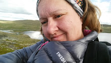
Here is us looking in the direction of our house and where we parked the car. We have hiked just over 4 km, or just under 2 miles. Our house is located about halfway between where we are standing and the bridge in the distance.

And here we are looking west, out into the great blue Atlantic.

North west, also eventually out into the North Atlantic ocean.

Finally north looking towards Sognafjorden.
The entire trip took us just under two hours, and you can bet we are very proud of our little ones!


1 comment:
looks so beautiful. i bet the air is clean and refreshing :)
Post a Comment